NASA Tracking Stations
Past and Present
_____________________
Alaska
Antarctica
Antigua, W.I.
Antofagasta
Ascension #1
Ascension #2
Ascension #3
Ascension #4
Ascension #5
Australia #1
Australia #2
Australia #3
Australia #4
Botswana
Bermuda #1
Bermuda #2
Bermuda #3
Bermuda #4
Bermuda #5
Bermuda Today
Bermuda #6
Buckhorn Station
Canary Islands #1
Canary Islands #2
Canton Island, So. Pacific
Corpus Christi, TX
Dakar, Senegal
Ft. Myers, FL
Goldstone, CA #1
Goldstone & JPL
Goldstone, CA #2
Apollo Site Dismantling
Grand Bahama Island
Guam
Guaymas, Mexico
Hawaii
Johannesburg, South Africa
Kano, Nigeria
Laser Ranging Systems
Madrid, Spain #1
Madrid, Spain #2
Madrid, Spain #3
Merritt Island, FL
Morocco
Ben Guerir Air Base
Newfoundland
NTTF / Greenbelt-GSFC, MD
Quito, Ecuador #1
Quito, Ecuador #2
Quito, Ecuador #3
Quito, Ecuador #4
Quito, Ecuador #5
Quito, Ecuador #6
Quito, Ecuador #7
Rosman, NC - ROS
Santiago, Chile #1
Santiago, Chile #2
Santiago, Chile #3
Santiago, Chile #4
The Seychelles
Tananarive, Madagascar #1
Tananarive, Madagascar #2
Tananarive, Madagascar #3
Tananarive, Madagascar #4
Tananarive, Madagascar #5
Tananarive, Madagascar #6
Tananarive, Madagascar #7
Tananarive via flickr
Clint Tuminalla Collection
MAD-AIR FIFTY-ONE
Written by John Laverty
Tracking Ships #1
Tracking Ships #2
Tracking Ships #3
White Sands, NM
Winkfield, England #1
Winkfield, England #2
Zanzibar
Project Mercury
Other Programs
Past and Present
______________
BFEC 25th Anniversary
"The Beginning"
25th anniversary brochure photos
The Charlie Fralick Collection
The Bendix Beam, Blossom Point
The King Ranch & others.
Apollo - DSN - Surveyor
Clem Savaikie Collection
Aircraft (C-118, 121's Apollo Sim.)
Aircraft (C47, C118 & Others)
"CONNIES"
ARIA Aircraft
Compat Vans (CTV)
Detrick Earth Station
U.S. NAVY / NESEA-SOSUS
NAVSPASUR
Space Surveillance System
NAMFI
NATO Missile Firing Installation
Misc. Photos
Pacific Missile Range
MSFN Control Center
Network Control Center
(msfnoc/nocc/ncc progression)
GSFC/STS-1 Support Team
Includes the BFEC team
MSFN Control Center
Apollo 5 Mission
Facilities Group
Management Photos #1
Management Photos #2
M & O Supervisors/Managers
MSFN , STADAN & STDN
Dodge Park Building
Network Support Group
Typical Worldwide BFEC Family
Peace Sun Program
FPS 14 RADAR Dedication
Fox Harbour, Labrador
Mt. Erebus Project
Carnegie-Mellon U's "DANTE"
1991 Retiree Group
1992 Retiree Group
Shemya, Alaska
BDA TLM TRACTOR AWARD
Camp Roberts, CA
AN/FSC-9 SATCOM
S-Band Field Strength Testing
Field Strength Testing, Goldstone et al
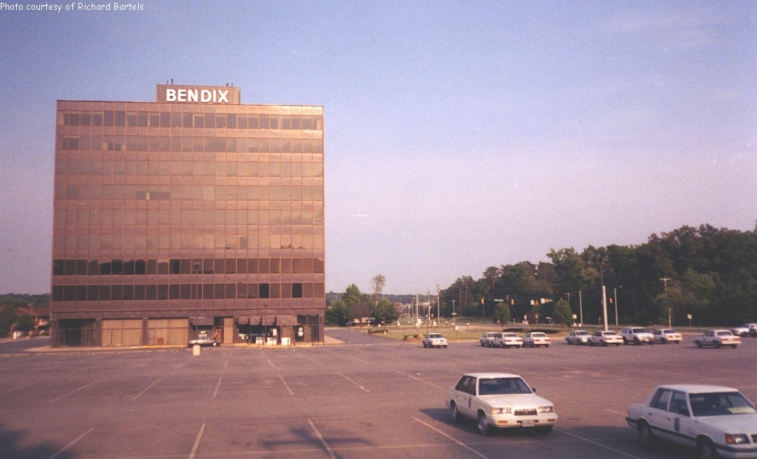
Bendix Aerospace Building
Goddard Space Center, Lanham MD
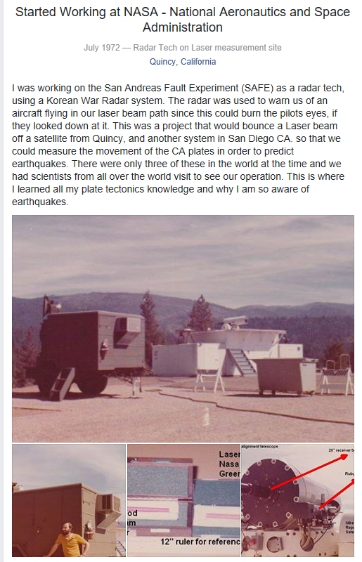
SAFE Project
Quincy, CA
_______
Various Picture
______
Various Pictures___________
below for their photo contributions.
(And to those whose names I have missed)
Bill Adams
John Adams
Larry Adams
John Bennett
John Best
Dave Bowers
Bob Brodkin
Jim Brophy
Ed Briggs
Dick Brown
Vic Brown (UK/WNK)
Bob Burns (NASA)
Fred Calderon
Jack Carlson
Dave Carroll
Randy Coffman
John Cornwell
Rich Degnan
Reid Drummond
Dan Duffy
Dwight Durkee
Chuck Edmonson
Lou Elliano
Joe Engle
Al Fong
Tom Foster
Chuck Fralick
Al Freedman
Al Ganch
Dave Ginavan
Robert Gould
David J. Gunther
Martin L. Hailey
Sean Hailey
David Herne (Australia)
Malcolm Higa
Mike Hogan
Bruce Hursey
Glenn Jacobs
Nick Jansen
Walt Keesey
Kerry T. Kilroy
Dan Kovalchik
Wendy Kruger
Dick Lahaye
Louis Lombardi
Jim MacDonald
Gustavo Maluenda
Christina Marlowe
Chuck Mason
Mike McDiarmid
John Michalik
Tom Millard
Marv Miller
Dave Mitchell
David Moore
Lenny Parker
Henry Rivas
Karla Rohland
Sam Sanders
Clem Savaikie
Bill Schoene - NASA
Alberto Segovia (Mexico)
Gene Smith
Glenn Smith
Gregory Smith
John Smith (UK/WNK)
Mark Smith
Jim Spaziano
George Spencer
Loyal Stewart
Greg Szekeres
C. Y. Thomas
Clint Tuminella
Bill Underwood
Stan Valeski
Andrew Wells (UK)
Mike Wilson
Bill Wood, W6FXJ
Steve Wooden
Don Zander
![[Image] , 2401 byte(s).](reunbak3.gif)
Late arrival
![[Image] , 3011 byte(s).](Reun11.gif)
June 2000 Luncheon Photos
January 2001 Luncheon Photos
June 2001 Luncheon Photos
former NASA station area. Most of the photos are dated October 23, 2003 by Google.
All of the notations that I have added to the photos are from how I remembered them
during the period of 1968-1971 when I was stationed there with the GRARR system.
LTAN1 = The Tananarive-Imerintsiatosika-NASA Station view.
LTAN2 = The "Hairpin Curve" on the road from Imerintsiatosika to the Station.
LTAN3 = The NASA Station (view #1)
LTAN4 = Imerintsiatosika 'Metropolitan Area'.
LTAN5 = The NASA Station (view #2)
LTAN6 = Expanded view of the Telemetry & Comm area.
LTAN7 = Expanded view of the GRARR/MSFN/Supply/Admin area.
LTAN8 = Example of newer imagery from Google Earth.
NOTE: If & when Google Earth upgrades the entire area to the newer, greener imagery
I wil make the change to all of the photos.
I welcome any additional information or corrections to my notes.
Gary Schulz
<webtek@bfec.us>
S. Schulz
<webtek@bfec.us>